Nicholas becomes a hurricane
Published 10:51 pm Monday, September 13, 2021
|
Getting your Trinity Audio player ready...
|
Nicholas becomes a hurricane as it brings heavy rains, strong winds and storm surges to portoins of the cenbtral and upper Texas Coasts.
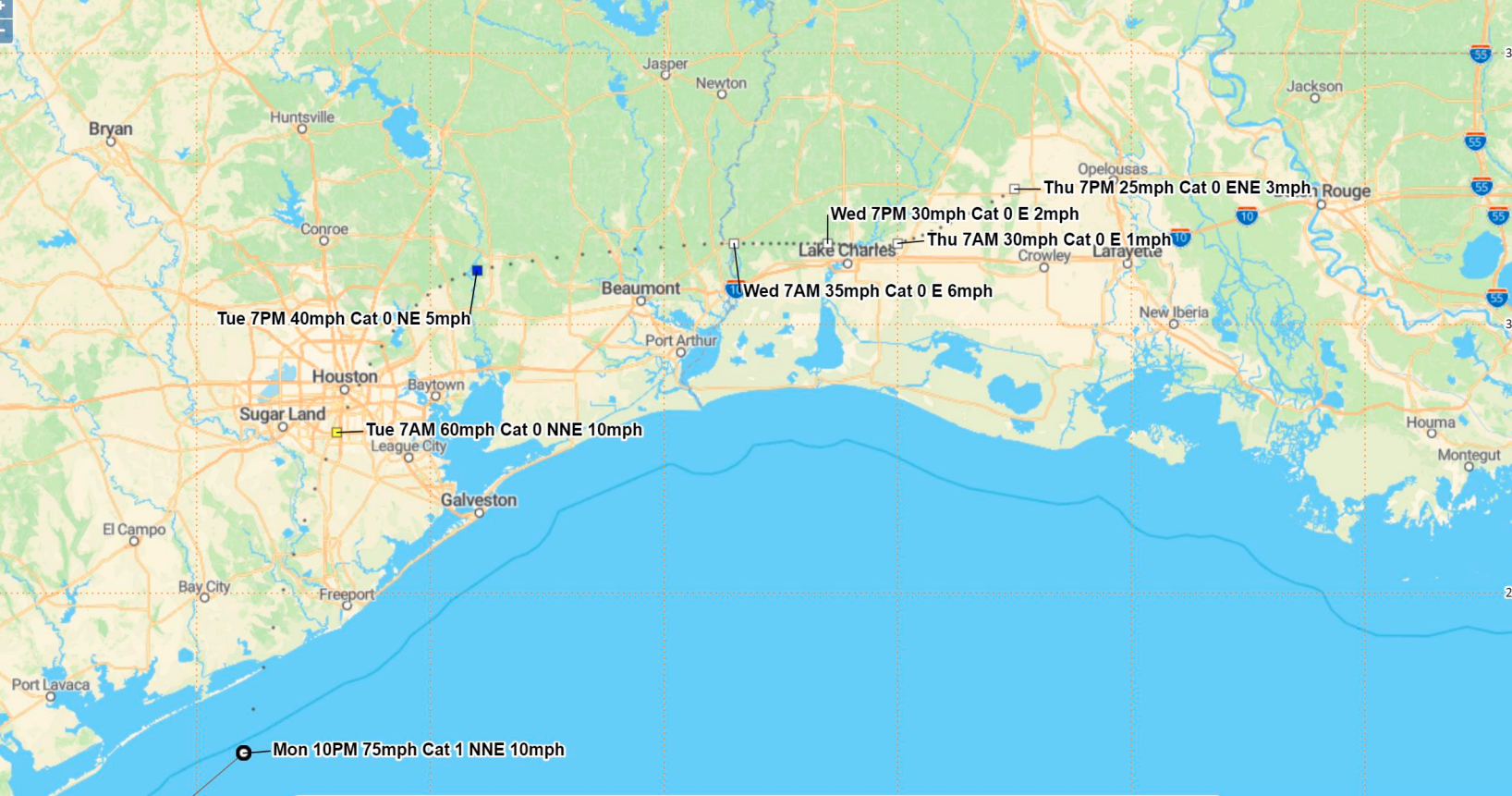
Nicholas has become a category one hurricane, approaching the Freeport to Matagorda TX coast. It is expected to move a little inland to the Houston area overnight, and then travel east along the I-10 corridor from Beaumont to Lake Charles and Lafayette Tuesday and Wednesday.
moving toward the north-northeast near 10 mph (17 km/h) and this general motion is expected to continue through tonight, followed by
a turn toward the northeast and a slower motion by late Tuesday and an even slower eastward motion on Wednesday. On the forecast track,
the center of Nicholas is expected to make landfall along the Texas coast in a few hours, move over extreme southeastern Texas on
Tuesday and early Wednesday, and over southwestern Louisiana later on Wednesday, according to a public advisory from the National Hurricane Center..
Maximum sustained winds are near 75 mph (120 km/h) with higher gusts. Little change in strength is likely before landfall,
followed by weakening after the center moves inland.
Hurricane-force winds extend outward up to 25 miles (35 km) from the center and tropical-storm-force winds extend outward up to 115 miles
(185 km). A Weatherflow station at Matagorda Bay recently reported a 1-minute sustained wind of 76 mph (122 km/h) gusting to 95 mph
(153 km/h).
The estimated minimum central pressure is 988 mb (29.18 inches).
Nicholas is expected to produce storm total rainfall of 6 to 12 inches, with isolated maximum amounts of 18 inches, across the
upper Texas coastal areas into Wednesday. Life-threatening flash flooding impacts, especially in urbanized metropolitan areas, are
possible across portions of the upper Texas Gulf Coast into far southwestern Louisiana.
Across interior southeast Texas into southern-central Louisiana and southern Mississippi, rainfall totals of 4 to 8 inches with locally
higher amounts near 10 inches are expected into Thursday. This rainfall may produce areas of considerable flash and urban
flooding.


