Tropical Storm Bill nears landfall
Published 11:04 am Tuesday, June 16, 2015
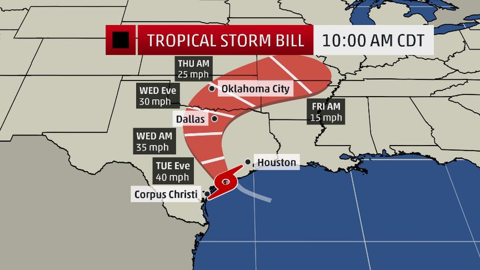
- Tropical Storm Bill's projected path through Texas and beyond. (Photo courtesy of Weather Channel)
Although Tropical Storm Bill will not make landfall in Southeast Texas, the storm system has definitely been the focus of attention the past several days.
Tropical Storm Bill has been a reminder of why Southeast Texans and residents of Southwest Louisiana should be vigilant each summer when Hurricane season arrives because it only takes a short amount of time for a storm to generate and have an impact on a large area.
FROM WEATHER.COM
Tropical Storm Bill is headed toward a landfall late this morning or early afternoon along the Texas coast and is poised to deliver more torrential rain and flash flooding to flood-weary parts of the South.
Before that happens, Bill’s wind field is already triggering coastal flooding in Texas.
At least a foot of water covered areas along FM 2031 south of Matagorda. Highway 87 was closed early Tuesday morning from Gilchrist to highway 124 on the east edge of the Bolivar Peninsula due to debris on the road. Galveston County emergency management reported yards were flooded in parts of Hitchcock and Bayou Vista, across the bay from Galveston Island.
The peak storm surge will occur as the center moves inland this morning, coinciding with an early morning high tide along the Upper Texas and southwest Louisiana coasts. Some minor coastal flooding is also possible as far east as southeast Louisiana and the Mississippi Gulf Coast.
Winds were already gusting over 50 mph on offshore oil rigs. One elevated rig just east of Port O’Connor measured a 65 mph gust at 7:45 a.m. CDT. Tropical storm-force winds will spread ashore this morning as the center moves inland.
Port O’Connor, Texas, reported tropical storm conditions Tuesday morning with sustained winds of 44 mph and a gust to 53 mph. Matagorda Bay, Texas, also reported tropical storm conditions with sustained winds of 41 mph and a gust to 53 mph Tuesday morning.
Expect the highest gusts, over 50 mph in a few spots, to occur, primarily to the east of the center from Matagorda Bay to Galveston and areas near Galveston Bay. Some trees, tree limbs may be downed and a some power outages are possible in these areas.
Flood watches have already been posted from Texas to southern Illinois in advance of Bill and its remnant.
Generally, widespread 3 to 5 inch rain totals can be expected, with locally much higher amounts likely where rainbands remain stationary or train over the same areas. Rain rates of 2-4 inches per hour, at times, are possible.
This is an area that has already had record rainfall and flooding in May, so additional heavy rainfall will quickly trigger renewed flash flooding and may eventually worsen river flooding still ongoing.


