National Weather Service outlines severe weather threat for Thursday in Southeast Texas
Published 6:06 am Monday, February 27, 2023

|
Getting your Trinity Audio player ready...
|
The National Weather Service has announced the potential for severe weather late Thursday night.
A Slight (level 2 out of 3) to Enhanced (level 3 out of 5) Potential Risk for severe Thunderstorms exists.
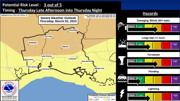
(Courtesy of the National Weather Service)
This includes damaging straight line wind gusts, large hail and a few tornadoes, including the potential for strong tornadoes.
The Enhanced Potential Risk is roughly north of the Interstate 10 corridor, and the Slight Potential Risk is along and south of the Interstate 10 corridor.
Isolated supercell thunderstorms with the potential for tornadoes, damaging wind gusts and large hail may develop late Thursday afternoon into early evening.
Then thunderstorms with the potential for damaging wind gusts, a few quick spin up tornadoes and large hail are expected to form into a line Thursday evening into Thursday night.
Confidence is increasing in the severe weather potential and is around a medium level with the event still four days out.
The exact timing and details of the impacts will still need to be ironed out over the next few days, weather officials said.