National Weather Service warns of thunderstorms southeast of Beaumont-to-Alexandria line
Published 7:58 am Tuesday, January 24, 2023

|
Getting your Trinity Audio player ready...
|
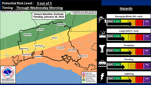
There is an Enhanced Risk (3 out of 5) for severe weather across deep Southeast Texas and much of Acadiana (generally along and south of a Beaumont to Oplousas line), according to the National Weather Service.
The remainder of the forecast area is in either a Slight Risk (2 out of 5) or Marginal Risk (1 out of 5).
Damaging wind gusts and possible tornadoes are the primary threats with these storms, with strong tornadoes possible in the Enhanced Risk area.
(Courtesy of the National Weather Service)
Frequent cloud to ground lightning will also be possible.
Meanwhile, a Slight Risk (2 out of 4) for Excessive Rainfall remains in place for essentially the entire forecast area except for lower Acadiana.
Expect most locations to receive between one and three inches of rainfall, with locally higher amounts possible…these heavier rains could produce localized flooding.
Aside from severe weather and heavy rains, very gusty gradient winds are expected.
Wind gusts of 40 to 50 mph may occur outside of thunderstorms southeast of a Beaumont to Alexandria line during this afternoon.
Showers and scattered thunderstorms have already developed, however stronger thunderstorms are not anticipated until afternoon.
The convection will eventually move out of the area beginning late this evening.