Here’s what weather officials say Southeast Texas residents should expect with severe weather today
Published 8:05 am Wednesday, January 18, 2023
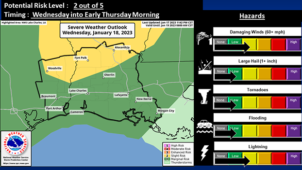
- (Courtesy of the National Weather Service)
There is the responsibility of heavy rain and severe storms today across Southeast Texas.
According to the National Weather Service, there is a Slight Risk (2 out of 5) for severe weather in place for the northern portion of the region.
A Marginal Risk (1 out of 5) is in place across the rest of the region.
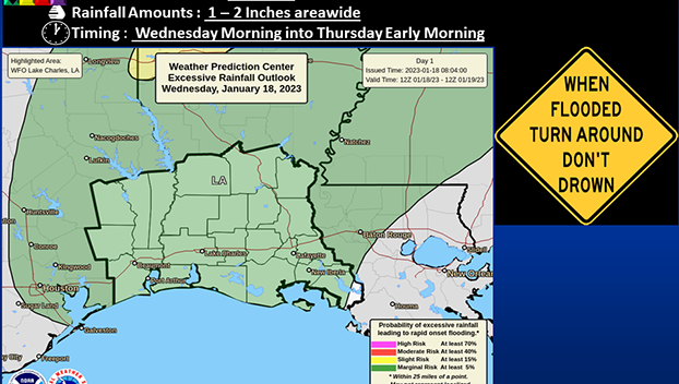
(Courtesy of the National Weather Service)
A Marginal Risk (1 out of 4) for Excessive Rainfall is also in place for the entire region.
Damaging wind gusts look to be the primary threat with these storms; however, a brief tornado and large hail cannot be ruled out.
Locally heavy rainfall leading to urban type flooding and frequent cloud to ground lightning will also be possible.
Showers and scattered thunderstorms will begin to develop late this morning in Southeast Texas and the rest of the area into the afternoon.
A squall line is then expected to move across the region late this afternoon or evening. The squall line should exit the region by midnight or very early Thursday morning.
Confidence remains low in how much, if any at all, discrete activity will develop late morning/afternoon and if any of these storms will be able to fully tap into the severe potential.
Confidence is moderate for the severe weather threat within the squall line late this afternoon into very early Thursday morning.