Wind gusts, large hail, tornadoes and cloud-to-ground lightning part of potential risk this week
Published 6:48 am Monday, November 28, 2022

|
Getting your Trinity Audio player ready...
|
There is a severe and heavy rainfall potential Tuesday into Tuesday night for Southeast Texas.
According to the National Weather Service, there is a slight risk potential (level 2 out of 5) for storms that develop to become severe.
This potential includes all modes of severe weather, including damaging wind gusts, large hail and a few tornadoes, along with occasional cloud to ground lightning.
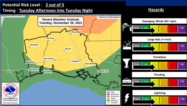
(Courtesy of the National Weather Service)
In addition, there is a slight risk potential (level 2 out of 4) to marginal risk potential (level 1 out of 4) for excessive rainfall that may lead to flooding.
The stronger storms will produce intense rainfall rates of 1 to 3 inches per hour that may cause flooding of urban poor drainage areas and roadways, as well as locations where grounds are still wet from recent rainfall.
The slight risk potential (level 2 out of 5) is for the entire area except right along the coast and the lower Atchafalaya Basin, as well as lower Southeast Texas, where a marginal risk potential (level 1 out of 5) is outlined.
First there is a forecast of isolated to scattered thunderstorms Tuesday afternoon and early evening.
Then bands of thunderstorms possibly forming into a squall line ahead of a cold front Tuesday night.