National Weather Service updates what, when SETX can expect bad weather on Monday
Published 9:54 am Monday, November 14, 2022

|
Getting your Trinity Audio player ready...
|
According to the National Weather Service, there is a marginal risk for severe storms and excessive rainfall today in Southeast Texas.
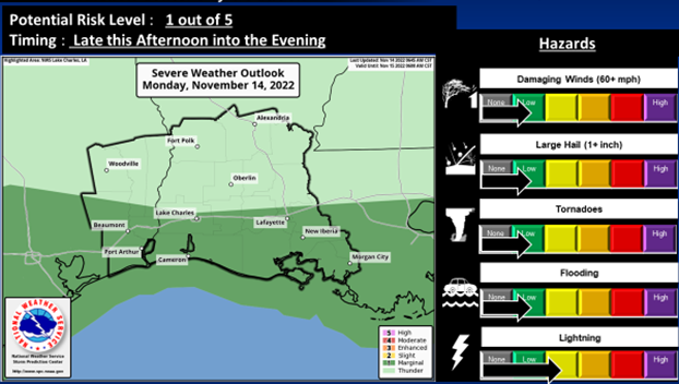
(Courtesy of the National Weather Service)
A low pressure system is expected to develop Monday afternoon and move right along the coast Monday night.
This system will bring widespread showers and a few thunderstorms. From along the I-10 corridor south into the coastal waters, these thunderstorms will bring the potential for severe weather and excessive rainfall.
The Weather Service said there is a marginal risk potential for severe storms, all modes including damaging winds, large hail, and quick spin up tornadoes.
The marginal risk potential is also for excessive rainfall that may lead to flooding.
Rainfall amounts are expected from 1 to 2.5 inches, which may fall in a short period of time.
The bad is to concentrate mainly along and south of the I-10 Corridor most likely in Southeast Texas from 5 to 9 p.m.