Disorganized area of showers and thunderstorms expected to impact SETX this week
Published 9:29 am Monday, June 27, 2022

|
Getting your Trinity Audio player ready...
|
Weather officials are monitoring three systems for tropical development as of Monday morning.
The first is a disorganized area of showers and thunderstorms over the north central Gulf of Mexico associated with a surface trough.
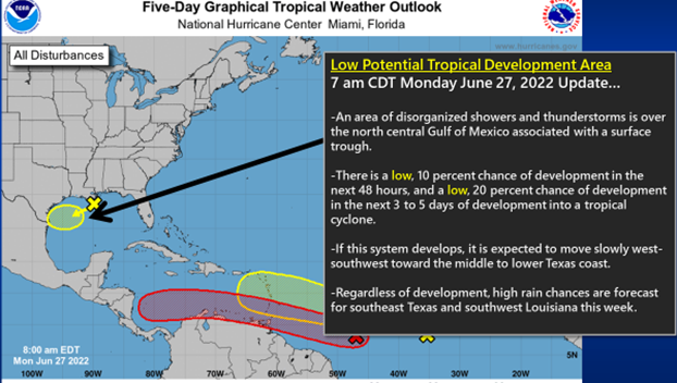
(Courtesy of the National Weather Service)
There is a low (10 percent) chance of tropical development in the next 48 hours, and a 20 percent development chance through the next five days as it moves west-southwest toward the lower to middle Texas coast.
The only impact from this system for southeast Texas and southwest Louisiana is a high rain chance for this week.
The second is a tropical wave nearing the Windward Islands.
This wave has a high (70 percent) chance of tropical development in the next 48 hours and a 90 percent chance of development through the next five days.
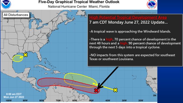
(Courtesy of the National Weather Service)
It will likely will be a tropical depression as it moves over the Windwards into the Caribbean Sea.
This system will continue to move westward into Central America and NO impacts are expected from this system for southeast Texas or southwest Louisiana.
The third is a new tropical wave in the middle Atlantic southwest of the Cape Verde Islands.
This system will move off to the west-northwest over the next several days.
It is still too early to say if this system will enter the Gulf of Mexico or have any impacts for Southeast Texas or southwest Louisiana.

(Courtesy of the National Weather Service)