2 a.m. TUESDAY UPDATE: Morning impacts expected across region
Published 5:03 am Tuesday, March 22, 2022

|
Getting your Trinity Audio player ready...
|
As of 2 a.m. Tuesday, weather officials said the expanded Moderate Risk (4 out of 5) area for severe weather expanded further southwest to include portions of southwest Louisiana.
“This change was prompted by the line of severe storms to our west moving very slowly eastward,” a release from the National Weather Service said. “Although the line of storms are moving slower than previous thinking, the timing of severe weather has not changed.”
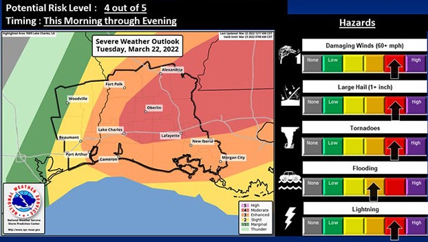
(Courtesy of the National Weather Service)
To summarize the severe threat across the area on Tuesday:
On Tuesday morning a line of strong-to-severe thunderstorms will move from west to east across the area from early morning through this evening.
Ahead of the line, a few scattered strong-to-severe storms could develop, primarily east of the Sabine River.
Tornadoes, large hail and damaging winds are possible, in addition to heavy rainfall.
Strong and gusty south-to-southwest winds can be expected ahead of the line, with winds becoming westerly behind it.
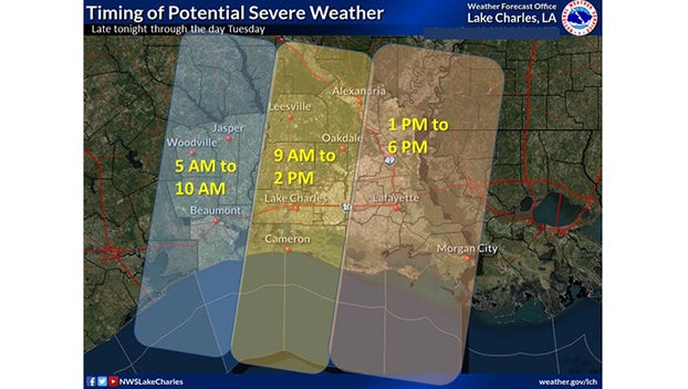
(Courtesy of the National Weather Service)