NWS Lake Charles tropical update: 4 p.m. 8.24.20
Published 4:37 pm Monday, August 24, 2020
|
Getting your Trinity Audio player ready...
|
Marco is not expected to cause any weather problems in our region tonight or tomorrow.
Laura is expected to make landfall between southeast Texas and south central Louisiana as a category two hurricane late Wednesday or early Thursday.
The average error for hurricane forecasts is 70 to100 miles off for two to three days in advance of landfall, so do not focus on the individual forecast points, but use the error cone instead!
Everyone should be preparing for a category three hurricane due to the average forecast errors when it comes to wind speeds (+/-15-20 mph for 2-3 days in advance).
——————————
Here is the forecast impacts for our region from Laura:
Winds: Hurricane force winds will be possible across the region starting late Wednesday and continuing Thursday.
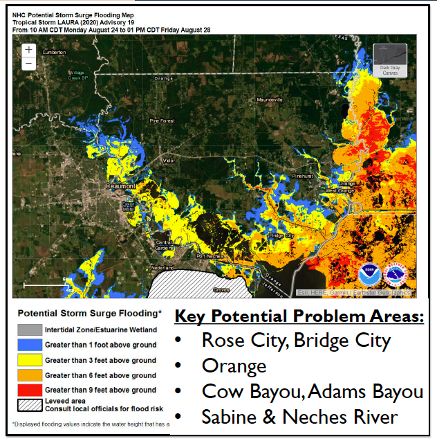
Storm Surge: At the coast, water could be over 10 feet above ground level. Depending on where Laura makes landfall, storm surge can back up rivers and bayous and flood over 30 miles inland.
Rainfall: Depending on where the rain bands form, 5 to 10 inches with locally 15 inches will be possible starting Wednesday into Thursday.
Tornadoes: Tornadoes will be possible in the eyewall as the hurricane approaches the coast, as well as outer rain bands starting Wednesday into Thursday.